
Autor: Karolína Hájková
-
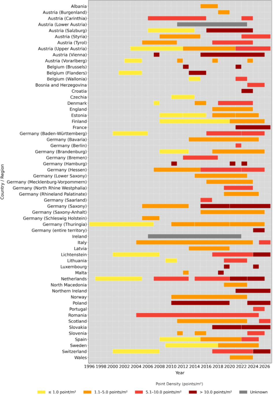
The 3D structure of vegetation and terrain in Europe is now almost completely mapped by airborne laser scanning
Author: Vítězslav Moudrý Understanding the three-dimensional structure of vegetation and terrain is fundamental for explaining how terrestrial ecosystems function, for assessing biodiversity, and for designing effective environmental policies. One of the most powerful remote sensing technologies for capturing this structure is airborne laser scanning (lidar). At the same time, lidar is a relatively expensive technology,…
-
FathomDEM raises the bar for the accuracy of global 30 m DEMs to new heights
Author: Petr Bašta Digital elevation models (DEMs) constitute fundamental data for various governmental, scientific, and commercial activities, serving a wide range of purposes in environmental sciences. The availability of global DEMs (GDEMs) has been improved considerably, especially in the past few years, which have been prolific in terms of the number of newly available bare-earth…
-

Europe Is Almost Fully Mapped in 3D Using Airborne Laser Scanning
Author: Vítězslav Moudrý Mapping the three-dimensional structure of vegetation (and terrain) is essential for understanding how terrestrial ecosystems function and for designing effective environmental policies. One of the most suitable remote sensing technologies for this purpose is airborne laser scanning (LiDAR). However, LiDAR is a relatively costly technology, and in Europe its acquisition is not…
-

Successful PhD Defense by Dominika Prajzlerová
Dominika Prajzlerová successfully defended her PhD dissertation focused on modeling bird diversity and distribution using multispectral satellite data. Her research demonstrated how remote sensing can effectively support biodiversity studies by addressing spatial scale, seasonality, and sampling bias, highlighting the strong potential of satellite data for large-scale ecological modeling.
-

Science Coffee Lecture: From Space to Policy
On Thursday, 11 December, a Science Coffee Lecture took place, led by Dr. Christine Wessollek (TUD), focusing on the use of Copernicus data for monitoring Common Agricultural Policy standards in administrative practice. The event included an expert discussion and demonstrations of innovative teaching methods, such as the flipped classroom, along with the exchange of teaching…
-

Improving Canopy Height Models in Temperate Regions: The Key to Accurate Forest Monitoring
Author: Vojtěch Barták Canopy height is one of the most important characteristics of forest structure. It is closely linked to stored biomass, forest productivity, and biodiversity. As we face increasing pressure from climate change and environmental degradation, consistent global monitoring of forest canopy height is crucial for understanding the state of our ecosystems and making…
-

How to Cool Down Urban Heat
Author: David Moravec Cities are getting hotter. As concrete, asphalt, and dense apartment blocks increasingly replace natural areas, urban areas often heat up significantly more than surrounding rural zones in hot weather. This phenomenon — known as the “urban heat island” — isn’t just about discomfort: it can affect public health, energy demand, and overall…
-

Invited Lecture by Research Professor Eija Honkavaara: Towards Autonomous Use of Drone Technology for Forestry Applications
Author: Jan Komárek As part of the ongoing seminar series on environmental monitoring and geospatial technologies, we had the pleasure of hosting Research Professor Eija Honkavaara from the Department of Remote Sensing and Photogrammetry at the National Land Survey of Finland. Her invited lecture, entitled “Towards Autonomous Use of Drone Technology for Forestry Applications”, offered…
-

Novel Method for Correcting Observer-Specific Bias in Species Distribution Models
Author: Petr Balej The prediction accuracy of Species Distribution Models (SDMs) is often compromised by sampling bias in species occurrence records. This issue is widespread in collaborative databases like the worldwide GBIF, iNaturalist, and the local Czech Species Occurrence Database. These platforms are filled with opportunistic species records of various quality collected by both expert…
-

“Cultivated lands: blind spots in global biodiversity data,”
A new article published in Trends in Ecology & Evolution draws attention to a surprising blind spot in global biodiversity research — cultivated lands. Although farmland covers almost half of the world’s habitable land, it remains underrepresented in open biodiversity data. The study, titled “Cultivated lands: blind spots in global biodiversity data,” was co-authored by…