
Author: Petr Bašta
Digital elevation models (DEMs) constitute fundamental data for various governmental, scientific, and commercial activities, serving a wide range of purposes in environmental sciences. The availability of global DEMs (GDEMs) has been improved considerably, especially in the past few years, which have been prolific in terms of the number of newly available bare-earth GDEMs. FathomDEM, one of the most recent datasets, promises superior performance across a diverse range of landscapes.
What did the study focus on?
- Nationwide validation of FathomDEM over Czechia using LiDAR dataset
- Accuracy assessment of 11 global 30 m DEMs for elevation and terrain metrics.
In our study, we focused on validating FathomDEM, providing the first independent country-wide assessment of its accuracy. To assess whether this expected superiority holds, we provide a comparison of vertical accuracy and the accuracy of derived terrain slope and ruggedness with six original GDEMs (e.g., Copernicus GLO-30 and TanDEM-X EDEM) and four bare-earth GDEMs (e.g., FABDEM and GEDTM).
Key findings
- Bare-earth GDEMs outperform originals; FathomDEM shows best overall accuracy;
- FathomDEM reduces RMSE by up to 11 m in forested areas compared to original GDEMs;
- FathomDEM proved to be a milestone in global terrain mapping, with a recommendation for all environmental applications.
Our results found clear differences between the two evaluated categories of GDEMs (original vs bare-earth), with original GDEMs being substantially less accurate than bare-earth GDEMs. Across all land cover categories, the best accuracy was achieved by the FathomDEM, followed by GEDTM or FABDEM.
Among all evaluated datasets, the FathomDEM consistently achieved the highest accuracy across all slope categories and land cover types, with RMSE values of 2.8 m in forests and below 1 m in urban and non-forested areas. In forest areas, such an RMSE is approximately 2.1–3.6 m lower than the RMSE of other bare-earth GDEMs and 7.1–10.9 m lower than that of the original GDEMs.
With regard to the terrain characteristics derived from GDEMs, the bare-earth GDEMs generally performed better again, with FathomDEM being the clear winner, on gentle and moderate terrain (especially in forested areas). However, the original GDEMs matched the performance of the bare-earth GDEMs on steep terrain and outside forested areas.

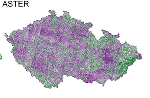
Figure: Spatial distribution of height differences between the assessed GDEMs and the reference ALS-derived DTM
Why this matters
Despite the fact that the vertical accuracy of all assessed GDEMs, as well as of the derived terrain variables, was affected by slope and land cover, the FathomDEM demonstrated the highest level of accuracy and the most consistent performance across varying slope and land cover conditions. Furthermore, the results of this study demonstrate the success of other bare-earth GDEMs in removing vegetation and/or buildings, and their superior accuracy in comparison to original DEMs.
These results underscore the necessity of ongoing development of bare-earth GDEMs and demonstrate that FathomDEM represents a substantial advancement in global terrain mapping and associated environmental modelling.

Figure: Effect of slope on the GDEMs‘ accuracy (ME, RMSE) in forest, non-forest, and urban areas. Note the improved accuracy of bare-earth GDEMs (dashed lines) compared to the original GDEMs (solid lines).