
Author: Vítězslav Moudrý
Understanding the three-dimensional structure of vegetation and terrain is fundamental for explaining how terrestrial ecosystems function, for assessing biodiversity, and for designing effective environmental policies. One of the most powerful remote sensing technologies for capturing this structure is airborne laser scanning (lidar). At the same time, lidar is a relatively expensive technology, and in Europe its acquisition is not centrally coordinated. Decisions about whether, how, and how often data are collected are made at national or regional levels. Despite this fragmentation, an extraordinary achievement has taken place over the last 15 years: almost the entire European continent has now been mapped using airborne laser scanning.
However, data availability is only part of the story.
Just as fragmented as data acquisition is data access. Airborne laser scanning data are managed by national or regional authorities, are not always openly available, and even when they are, obtaining them can be technically or administratively demanding. In addition, lidar datasets are large and require specific expertise and adequate computational infrastructure for processing. Together, these barriers substantially limit the use of lidar data at a continental scale.
These challenges motivated our recent study, conducted by an international team of researchers and published in Earth and Space Science. In this work, we mapped the availability and basic characteristics of airborne laser scanning data across Europe and explored pathways toward their broader and more systematic use. Our primary focus was on the potential to develop a pan-European vegetation height model and other structural metrics of vegetation. Importantly, we also demonstrated that currently available global canopy height models are substantially less accurate in representing vegetation height than lidar, even in regions where airborne lidar data are up to ten years old.
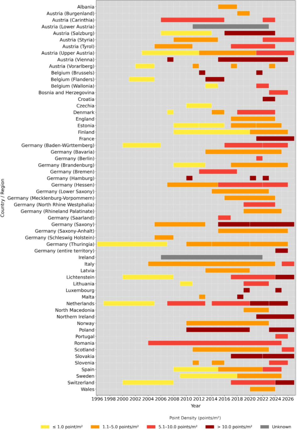
Out of 44 European countries, government institutions currently conduct airborne laser scanning in at least 33. The typical point density of available datasets ranges around 5 points per square meter, while more recent campaigns often reach substantially higher densities, increasing their suitability for detailed vegetation structure mapping. In most countries, point clouds are classified at least into basic categories such as ground, vegetation, buildings, and water. More detailed classes, such as power lines or bridges, are included less frequently.
The same data can also be used to generate highly accurate digital terrain models, which are already provided by most European countries. In contrast, derived vegetation metrics—such as canopy height, vertical structure, or structural heterogeneity—are only openly available in a small number of cases. Where such products do exist, they differ considerably in both the choice of metrics and the methods used to calculate them.
This is where we see both a major limitation of the current situation and a major opportunity. To enable the use of vegetation structure metrics in a truly pan-European context, coordination is needed from the outset. The goal should be a harmonized, continental-scale product that allows robust assessments of vegetation structure over large areas. Achieving this vision will require the development of a centralized data repository, a unified metadata catalogue, and targeted data acquisition in regions where airborne laser scanning is still missing. If successful, Europe has the potential to become a global leader in open, high-resolution 3D landscape data—with direct benefits for ecological research, nature conservation, and sustainable land-use planning.
For more details please see: https://doi.org/10.1029/2025EA004544


Vítězslav Moudrý also discussed this topic in an interview on Czech Television. (from minute 31 of the video)
https://www.ceskatelevize.cz/porady/1096902795-studio-6/226411010110112