
Author: Jan Komárek
Drones have revolutionised environmental monitoring, promising on-demand, high-resolution data collection in places satellites can’t reach. But beneath the hype lies a harsher reality: weather. I analysed meteorological records from 31 Czech locations (2016–2024) and found that drones are actually grounded about 75 % of the time. Here’s why—and what we can do about it.
1. The Data Speaks
By applying six operational thresholds—precipitation, temperature, wind speed and more—to eight years of weather data, we observed:
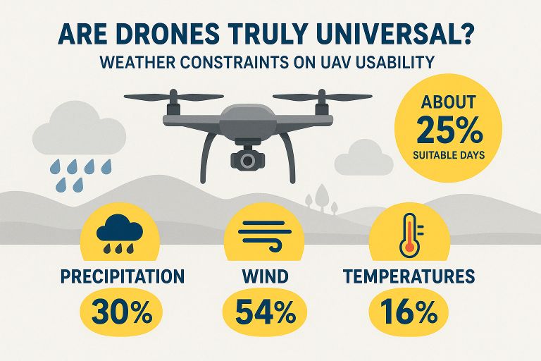
- Only ~90–110 flight-ready days per year (≈ 25 %)
- 30 % of days lost to even light rain (> 1 mm)
- 47 % of days with gusts over 8 m/s
- 15 % of days with subzero temperatures (and rising heatwaves)
Climate change has shaved a few freezing days off the calendar, but hotter summers and gustier winds have offset any gains.
2. Why Weather Matters
Even when legal limits allow flight, atmospheric conditions degrade data quality:
- Wind instability causes motion blur, misaligns mosaics and ruins georeferencing.
- Raindrops on lenses scatter light and obscure targets.
- Clouds, haze and fog disrupt radiometric consistency—critical for multispectral and hyperspectral sensing.
- Extreme temperatures drain batteries faster and risk electronics failure.
Too often, studies omit detailed weather logs, making it hard to reproduce results or compare across sites.
3. Moving Beyond “Fly-and-Hope”
To close the gap between drone potential and reality, we need:
Nowcasting & Adaptive Planning
- Integrate short-term weather forecasts into flight-planning tools.
- Automate go/no-go decisions and dynamic rerouting in-app.
Standardized Weather Documentation
- Record and publish detailed meteo-logs alongside each mission.
- Share thresholds used, sensor settings and actual conditions.
Emerging AI-driven dehazing algorithms, multi-sensor fusion and real-time geo-fencing promise to push operational windows—but only if we start by acknowledging the limits. Comparative studies across diverse climates will help build a global picture of drone “flyability.”
Join the Conversation
Drones can still be game-changers for environmental science—but only when we design workflows around Mother Nature, not against her. I welcome your thoughts on:
- Best practices for weather-adaptive mission planning
- Experiences with extreme-weather drone deployments
- Ideas for open-source tools to log and share flight-weather data
🔗 Read the full Perspective: https://doi.org/10.1002/ntls.70003