
Authors: Vítězslav Moudrý, Jana Marešová, Petr Bašta
I am sure you are aware of my passion for Digital Elevation Models (DEMs) and their validation. It’s been a few years since we validated the then brand-new TanDEM-X DEM (https://doi.org/10.1016/j.rse.2020.111724), and since then, the number of available global DEMs has grown rapidly, just to name a few: Copernicus DEM, Forest And Buildings Removed Copernicus DEM (FABDEM), and Continental Europe Digital Terrain Model. I guess it’s not surprising that we wondered how they would do. So, in a recent study, we focused on their accuracy. Importantly, we’ve teamed up with our colleagues in the Department of Water Resources and Environmental Modeling to also evaluate the usability of global DEMs for hydrological applications, such as river network delineation.
Several earlier studies have investigated the influence of DEM resolution and data sources on derived stream networks accuracy and showed improved stream network delineation with increasing resolution. However, bare‐earth DEMs with removed vegetation offsets were not employed in those analyses as they became available only relatively recently. Therefore, our study is the first one to assess whether a higher resolution DEM (e.g., TanDEM-X at 12 m resolution) or DEM with vegetation offset removed (e.g., FABDEM at 30 m resolution) is more suitable for accurate stream network delineation. Interestingly, however, we found that the accuracy of derived stream networks was more affected by terrain slope and land cover than by the vertical accuracy and horizontal resolution of DEMs. The presence of dense tall vegetation and increasing slope are well known factors that negatively affect the accuracy of global DEMs, but notably we found opposite effects on stream network delineation. Stream network delineation performed poorly in non‐forested areas and relatively well in forested areas, and increasing slope improved the stream delineation performance.
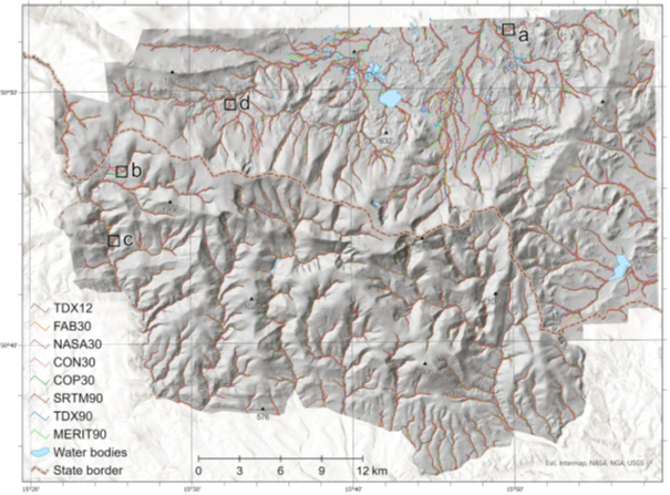
River networks generated using the eight DEMs. Boxes indicate the positions of sites shown in detail in the next figure
The bare-earth DEMs (e.g. FABDEM) were among the best global DEMs for stream network delineation. They outperformed the finer resolution TanDEM‐X at 12 m in most cases. Using the higher resolution TanDEM-X DEM provided better detail and allowed the delineation of meandering streams with better accuracy than coarser resolution data, but the increased resolution also increased the need for effective vegetation bias removal. For example, the increased resolution results in the erroneous delineation of streams in areas with notable changes in vertical accuracy, such as roads within a forest. Such errors are, however, relatively easy to detect using visual inspection and transportation network data; this issue should, therefore, not be viewed as a reason to use coarse resolution models.
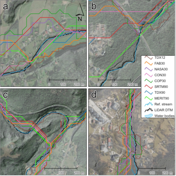
Errors in stream network delineation typically appeared in areas (a) that were relatively flat, (b) of notable changes in DEMs vertical accuracy (e.g., roads or forest edges), (c) of meandering streams, (d) with linear vegetation along the streams.
It should also be pointed out that most studies validating global DEMs typically evaluate only vertical errors. However, this approach may fail to predict the effect of errors in DEMs on their final applications. Indeed, our results show that vertical accuracy alone does not reflect how well DEMs perform in stream network delineation. Alternatively, the quality of DEMs can be assessed in terms of the quality of the produced output, that is, in the context of a particular type of analysis. We therefore propose that the performance of stream network delineation should be included in the quality assessment of global DEMs.
If you are interested in more details, you can read the full paper in Earth and Space Science:
https://doi.org/10.1029/2024EA003743
Other new models are emerging that we did not include in the study. For example, there are two new products derived from the data acquired during the German TanDEM-X mission: the TanDEM-X 30m Edited DEM, which has been automatically edited to interpolate and fill voids in the data, and the WorldDEM Neo DTM, a commercial product developed by Airbus Defence and Space. If you’re interested in the performance of these DEMs, stay tuned for upcoming updates.