
Author: Kateřina Gdulová
Global radar-based Digital Elevation Models (DEMs), such as TanDEM-X and SRTM, are widely used to represent different aspects of the Earth’s surface. However, one key question often goes unaddressed: Are these DEMs digital terrain models (DTMs) or digital surface models (DSMs)?
These models are used as both DTMs and DSMs, sometimes without critically assessing the appropriateness of the given choice. This dual usage can lead to confusion or even errors in interpretation. Therefore, the DEM user needs to be aware of what their model most closely represents and how this may affect their research.
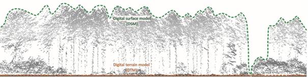
Digital surface model (DSM) and digital terrain model (DTM) in a location with dense forest coverage (adopted from Moudrý et al. 2023).
Same Dataset, Different Disciplines
Whether a DEM is used as a DTM or DSM often depends on the researcher’s background and the aims of their study. Different disciplines have varying requirements and focus areas, influencing DEM interpretation and use. In Gdulová et al. (2021), we noted that what can be rightly considered a bias in some applications (i.e., hydrological applications requiring bare ground) can be an exploitable signal in others (such as the estimation of forest canopy height).
In hydrological studies, global DEMs are often considered as DTMs, and the recorded vegetation is perceived as bias (e.g., Hawker et al. 2019, Kumar et al. 2020, Pa’suya et al. 2022, Rizzoli et al. 2017). On the other hand, some applications explicitly use DEMs as DSMs – for example, to estimate canopy height (e.g., Sadeghi et al. 2018, Schlund et al. 2019) or to assess changes in canopy height (Schlund et al. 2023). In Gdulová et al. (2021), we used SRTM and TanDEM-X as DSMs to detect deforestation by using their acquisition time difference.
Why It’s Hard to Label TanDEM-X
Classifying current global radar-based DEMs as either DTM or DSM is difficult. Radar waves in the C- or X-band only partially penetrate the vegetation. As a result, these DEMs fall somewhere between the two categories.
In Gdulová et al. (2020), we evaluated TanDEM-X DEM against both DTM and DSM references and found that although the vegetation height is underestimated, it is closer to a DSM. A similar conclusion was reached by Bandura & Gallay (2022), who showed that using TanDEM-X DEM as a DTM leads to a major terrain overestimation. This finding is not surprising, as it is well known that the X-band radar wave penetrates only a few meters into the vegetation (Martone et al. 2018, Schlund et al. 2019, Schlund et al. 2023).
Why It Matters
Misinterpreting a DEM’s nature can lead to serious application errors. In flood modeling, vertical errors can lead to incorrect stream network delineation and faulty flood extents (Archer et al. 2018, Carlson et al. 2024, Garrote 2022, Hawker et al. 2018). In geomorphology, using a DSM instead of a DTM can lead to inaccurate identification of valleys in forested areas (Bandura & Gallay 2022, Hofierka et al. 2018).
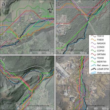
Errors in stream network delineation. Examples of areas (a) that were relatively flat, (b) with notable changes in DEMs vertical accuracy (e.g., roads or forest edges), (c) of meandering streams, (d) with linear vegetation along the streams (adopted from Marešová et al. 2024).
Some studies attempt to correct for vegetation during pre-processing (Archer et al. 2018, Kulp et al. 2018). However, Garrote (2022) advocates using raw DEMs to meet better the needs of typical users such as public authorities responsible for flood risk management in developing regions.
Scientific (Dis)agreement
Even among scientists, perceptions vary. In our first study on TanDEM-X DEM vertical accuracy (Gdulová et al. 2020), reviewers appreciated our decision to evaluate TanDEM-X against both DTM and DSM references. This motivated us to include a similar approach in a second study(Marešová et al. 2021). Yet this time, the reviewers suggested that using DTM to evaluate a global DEM (DSM) is inappropriate and unacceptable.
To respond, we provided a table showing what reference surface was more commonly used by studies evaluating TanDEM-X DEM (see Table 1 in Gdulova et al. 2021). The results suggest a trend: TanDEM-X DEM is more widely considered a DTM. This may partly reflect data availability—ground terrain data are often more accessible than reliable canopy height datasets.
A Way Forward: Evaluate Both
Bielski et al. (2024) proposed a more robust framework: include comparisons with both DTM and DSM where possible and appropriate. This stems from the fact that global DEMs are used both ways, sometimes without critically assessing the appropriateness of the given choice.
Not many studies adopt DTM and DSM when validating global DEMs (see Bandura & Gallay 2022, Wessel et al. 2018). DEM validation should ideally include airborne or spaceborne laser altimetry (e.g., ALS) to assess vertical accuracy relative to ground and canopy surfaces. Guth et al. (2021) and Guth & Geoffroy (2021) used such methods to demonstrate how DEM accuracy shifts depending on land cover.
More broadly, DEM users should be educated about the distinction between DTMs and DSMs and how it relates to their specific applications. By clearly documenting whether a DEM behaves more like a DTM or a DSM, we can avoid misinterpretation and promote better use of global elevation data in science and policy.