
In a newly published study, researchers led by Vítězslav Moudrý have conducted a detailed analysis of three global canopy height maps: the Global Forest Canopy Height (GFCH), the High-Resolution Canopy Height Model of the Earth (HRCH), and the Global Map of Tree Canopy Height (GMTCH). The study, titled „Comparison of three global canopy height maps and their applicability to biodiversity modeling: Accuracy issues revealed,“ delves into the accuracy and potential limitations of these models, particularly in their use for biodiversity modeling.
Importance of Canopy Height Data
Canopy height plays a critical role in understanding forest ecosystems, which cover over 4.1 billion hectares of the Earth’s surface. Vertical forest structure is closely linked to aboveground biomass, productivity, and biodiversity. Thus, accurate canopy height data is essential for ecological studies, particularly those focused on biodiversity modeling and habitat quality assessment.
With the recent advent of global canopy height maps derived from satellite and LiDAR data, researchers now have tools that can continuously monitor forest height at a global scale. However, the accuracy of these models and their sensitivity to environmental variables need careful evaluation, especially in biodiversity research, where subtle variations in habitat structure can have significant implications for species distribution and habitat use.
Key Findings
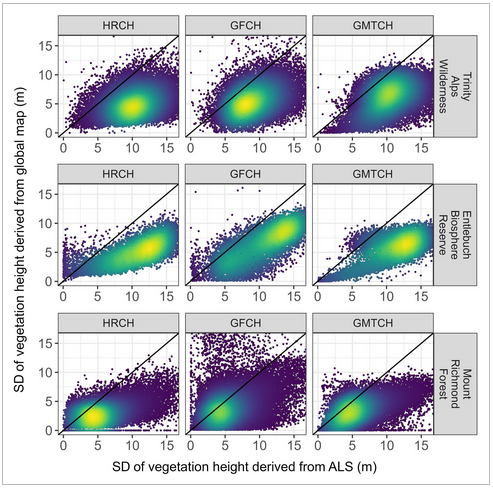
The study compared the GFCH, HRCH, and GMTCH against high-precision Airborne Laser Scanning (ALS) data across three diverse temperate regions—California, Switzerland, and New Zealand. The findings revealed notable discrepancies in the accuracy of these global maps:
- Root Mean Square Error (RMSE):
- GFCH exhibited RMSEs ranging from 10 to 18 meters.
- HRCH had RMSEs between 9 and 11 meters.
- GMTCH’s RMSE varied from 10 to 17 meters.
- Under- and Overestimation of Canopy Heights:
- Both GFCH and GMTCH consistently underestimated canopy heights, particularly for taller trees, while HRCH overestimated the height of low canopies and underestimated tall canopies.
- Impact on Biodiversity Modeling:
- Although the canopy height maps are useful for identifying basic relationships between species occurrence and canopy height, their inaccuracies can mischaracterize more complex indices, such as canopy height heterogeneity. This can lead to incorrect conclusions about species niches and habitat preferences.
- Sensitivity to Environmental Variability:
- The study found that global maps underrepresent habitat heterogeneity, a crucial factor in biodiversity. Canopy height heterogeneity, which influences the variety of ecological niches available for species, was consistently underestimated across all maps.
Implications for Biodiversity Modeling
The research underscores the importance of accurate canopy height data for biodiversity modeling. While global canopy height maps are valuable for large-scale assessments, their use in detailed habitat modeling may result in significant errors. The study calls for greater reliance on high-resolution local ALS data, especially in regions rich in such datasets, like Europe and the U.S., rather than global models that may introduce inaccuracies.
This comprehensive evaluation highlights the need for improved methods and data harmonization efforts to produce more reliable canopy height maps. For biodiversity conservation, where precise habitat characterization is essential, relying on local high-accuracy data rather than global models can lead to more informed decision-making and better conservation outcomes.
Conclusion
This research provides a crucial critique of current global canopy height maps and their applicability to biodiversity studies. While these models are important tools, their limitations must be recognized. For more precise biodiversity assessments, especially in temperate regions, the study suggests focusing on harmonizing local ALS data to produce more accurate canopy height information, ensuring that species conservation efforts are based on reliable and detailed data.
The study, published in Ecosphere, is a significant contribution to the ongoing efforts to improve the accuracy of forest height measurements and their applications in ecological research.
See the article in full: https://doi.org/10.1002/ecs2.70026