Author: Vitezslav Moudry
Global mapping of forest height is an extremely important task. However, measuring it at a detailed scale is challenging and has increasingly been supplemented by predictions based on various remote sensing data. Several global and continental canopy height maps have been released in recent years. Since I am naturally skeptical of predictions, I decided to take a closer look at some of the most significant ones: the Global Map of Tree Canopy Height, the Canopy Height Map for Europe, the High-Resolution Canopy Height Model of the Earth, and the Global Forest Canopy Height Map.

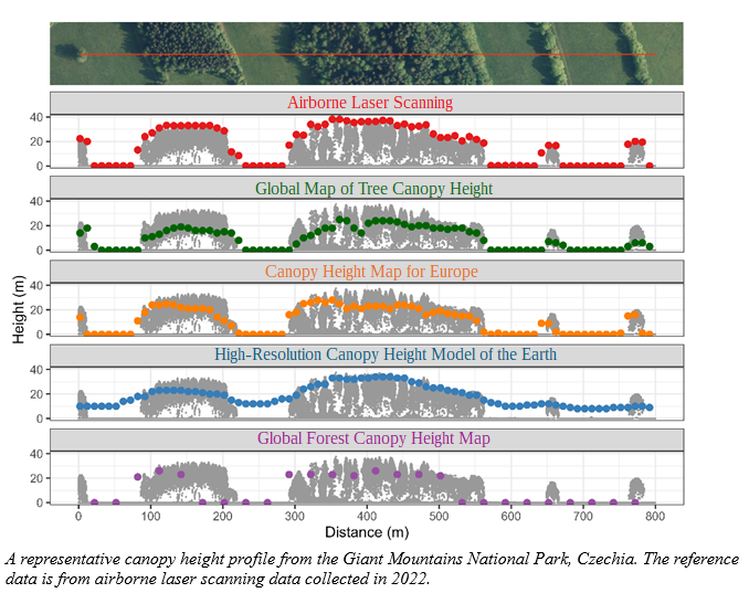
A representative canopy height profile from the Giant Mountains National Park, Czechia. The reference data is from airborne laser scanning data collected in 2022.
First, I evaluated how accurate these canopy height maps are using data from temperate areas in Switzerland, New Zealand, California, and Czechia. The results show that global CHMs typically underestimate canopy heights. The smallest underestimation was observed for the High-Resolution Canopy Height Model of the Earth. However, this map significantly overestimates the heights of low canopies, which is evident from the figure above. This has implications for another important aspect I explored: the sensitivity of global canopy height maps to changes in canopy height (i.e., how well they represent canopy heterogeneity). The High-Resolution Canopy Height Model of the Earth has limited ability to capture variations in canopy height, making the transition between forest and non-forest areas unclear. For instance, the mosaic of pastures and forests shown in the figure above appears as a continuous forest, with heights ranging from 10 to 30 meters. In contrast, the Global Map of Tree Canopy Height and the Canopy Height Map for Europe more effectively differentiate between forest and non-forest areas, thanks to the substantially higher resolution of their input data. On the other hand, the Global Forest Canopy Height Map has a resolution that is too coarse to capture individual trees or tree alleys.
One important application of global canopy height maps is biodiversity modeling, as habitat heterogeneity is a key factor determining biodiversity patterns. To explore this, I assessed how errors in global canopy height maps impact species distribution models. The results clearly demonstrate that using global canopy height maps for biodiversity modeling enables the estimation of simple relationships between species occurrence and canopy height. However, when derived indices such as canopy height heterogeneity are utilized, there is a significant decrease in the discriminatory ability of the models, leading to mischaracterization of species niches.
If you are interested in more details, you can read the full paper in Ecosphere:
https://doi.org/10.1002/ecs2.70026
I emphasize that local high-accuracy canopy height models, such as those derived from airborne laser scanning data, should be prioritized. These datasets are increasingly available through governmental agencies in Europe and other parts of the world. Even a 10-year-old airborne laser scanning dataset provides more accurate information than any predicted map so far. We discuss this in greater detail in a recent preprint: https://doi.org/10.31223/X5D70J.
